Resources
1. ESA Dataset
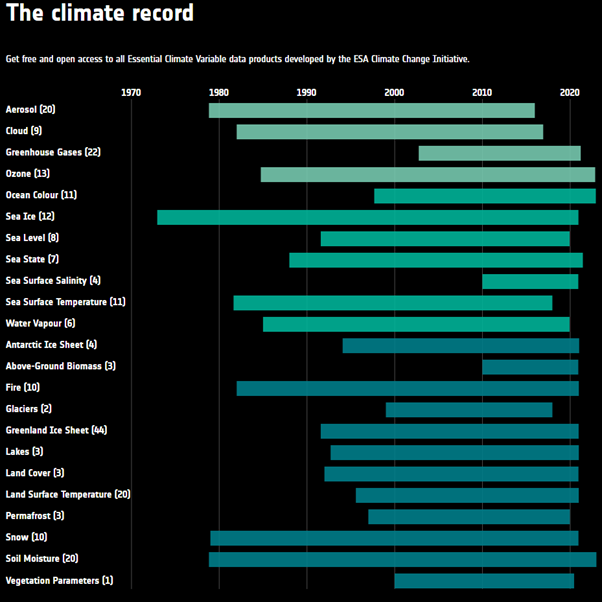
ESA Climate Change Initiative - this is where you find the data for this project
2. Matlab Course
MATLAB Course on Data Processing and Visualisation - this is a MathWorks course, it is 8 hrs long, you do not need to do it. It’s helpful for examples.
3. M_Map
M_Map, a downloadable mapping package for Matlab. They have lots of examples on how to plot maps on different projections.
4. ESA Globe Visualiser
5. Movie Maker
moviemaker.m is an example of some code to help create animations and save them as movies.
6. Structure example
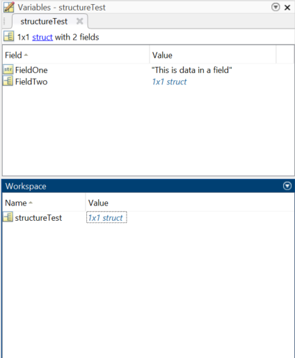
You can double-click on structs in the Workspace to access the fields within them. You can do the same thing in the Variables space to access fields within fields. Use dot indexing to access the different fields within a struct.
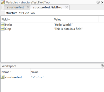
For instance, structureTest.FieldTwo is a struct within the structureTest struct.
7. Recommended datasets.
The ESA CCI consists of hundreds of datasets, some of which are harder to work with than others. Here we have highlighted a few recommended datasets to get you started. GetNet vs readCDF
Aerosol:
- Level 3 aerosol products from the Multi-Sensor UV Absorbing Aerosol Index (MS UVAI) algorithm, Version 1.7
- 1978 – 2015
- 8.1GB Total
- ~1.2MB Indiv.
Cloud:
- MERIS+AATSR monthly gridded cloud properties, Version 2.0
- 2003 – 2011
- 13.4GB Total
- ~120MB Indiv.
Greenhouse Gases:
- Column-averaged CO2 from GOSAT generated with the OCFP (UoL-FP) algorithm (CO2_GOS_OCFP), v7.0
- 2009 – 2015
- 1.7GB Total
- ~450KB Indiv.
Ozone:
- Merged Level 3 Limb Ozone Monthly Zonal Mean (MZM) Profiles, Version 2
- 2007 – 2008
- 3.1MB Total
- ~130KB Indiv.
Ocean Colour:
- Monthly climatology of global ocean colour data products at 4km resolution, Version 6.0
- 1997 – 2022
- 12GB Total
- 1GB Indiv.
Sea Ice:
- Sea Ice Concentration Climate Data Record from the AMSR-E and AMSR-2 instruments at 25km grid spacing, version 2.1
- 2002 – 2017
- 94.3GB Total
- ~9.4MB Indiv.
Sea Level:
- Time series of gridded Sea Level Anomalies (SLA), Version 2.0
- 1993 – 2015
- 1.2GB Total
- ~4.0MB Indiv.
Sea Surface Salinity:
- Monthly sea surface salinity product on a global grid, v04.41, for 2010 to 2022
- 2010 – 2022
- 2.7GB Total
- ~8MB Indiv.
Sea Surface Temperature:
- Advanced Very High Resolution Radiometer (AVHRR) Level 3 Collated (L3C) Climate Data Record, version 2.1
- 1981 – 2016
- 2.6TB Total
- ~55MB Indiv.
Water Vapour:
- Total Column Water Vapour monthly gridded data over land at 0.05 degree resolution, version 3.2
- 2002 – 2017
- 14.5GB Total
- ~70MB Indiv.
Fire:
- AVHRR-LTDR Burned Area Grid product, version 1.1
- 1982 – 2018
- 7.2GB Total
- ~16MB Indiv.
Greenland Ice Sheet:
- Greenland Ice Velocity Map Winter 2013-2014, v1.0
- 2013 – 2014
- 354MB Total
- 99MB Indiv.
Land Surface Temperature:
- Monthly multisensor Infra-Red (IR) Low Earth Orbit (LEO) and Geostationary Earth Orbit (GEO) land surface temperature (LST) level 3 supercollated (L3S) global product (2009-2020), version 1.00
- 2009 – 2020
- 90.9GB Total
- ~90MB Indiv.
Permafrost:
- Permafrost extent for the Northern Hemisphere, v3.0
- 1997 – 2019
- 3.4GB Total
- 150MB Indiv.
Snow:
- Fractional Snow Cover in CryoClim, v1.0
- 1982 – 2019
- 30GB Total
- ~2MB Indiv.
Soil Moisture:
- COMBINED product, Version 08.1
- 1978 – 2022
- 20GB Total
- ~1.5MB Indiv.
Vegetation Parameters:
- ESA Aerosol Climate Change Initiative (Aerosol_cci): Level 2 aerosol products from ATSR-2 (ensemble product), Version 2.6